
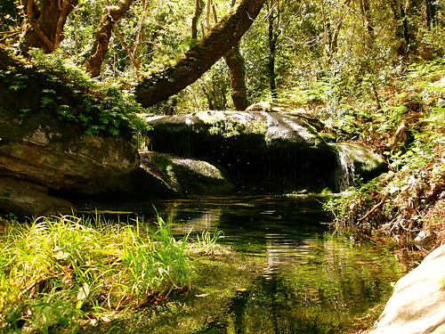
Piercing through an ancient forest
Δημοσιεύθηκε: 3 Ιουλίου, 2009 Filed under: choses vécues, exploring, hiking, ikaria, photography, stories | Tags: adventures, agrimi-mou, angelos, cons-pirates, eloquence, environment, flickr-photos, forest, Greece, ikaria, installation-in-nature, αγρίμι-μου, ικαρία, μονοπάτια, layers, new-trail, photos-flickr, preservation, preserve, principles, srd, summer 2007, trail-of-the-elves, trails, walk-hike-wander, what-it-takes 1 σχόλιο-

Trail of the Elves # 1

Comments

simonsterg
 says:
says:This looks like an enormous achievement, angeloska! It looks like there has been a lot of chopping! (At least you had elves to help you!)

isl_gr
says:@ ‘simonsterg’ : if you enlarge the image, you see on the footer it reads «Lothlorien College Graduates» !!!
@ ‘angeloska’ : x x x x x x x x

angeloska
says:You are giving me new strength!
In return here is a small part of the story. This trail was almost an imaginary one, featuring only in an old Italian map of 1943 and in Elenis imagination and *unusual sources* (her old neigbours’ tales). The distance was about 2,5 km cutting through deep tall makia. We started cittung from both sides, one day from the east and the other from the west, with no more sense of direction but the zig-zag flow of a rivulet running next to the alleged path. The hard evidence whether the path existed, as well as my extreme worry was if the two tunnels would eventually meet someplace. They DID! I felt like opening a champaigne bottle.
Posted 6 months ago. ( permalink )simonsterg
says:That bit about the 1943 italian map sounds sort of romantic § – a hint from an odd old source – ideally you should have lost the map – kind of like a Borges tale, you know the sort of thing…
And you have made this perhaps imaginary path into… a REAL ONE – a Second Eupalinos! ¤ Champagne corks ought to be flying!
footnotes:
§ not that Eleni’s imagination isn’t also, of course, romantic – and the *unusual sources* very likely accurate…¤ if that’s hyperbole it’s just in a celebratory way – not an attempt at irony (which I dislike)
angeloska
says:I lost the map! As soon as I found it I lost it! I had only one glimpse of it. Then a veil of secrecy came and covered …
Eupalinos? I had thought of him. He used stereometry and trigonometry. He was given an awful amount of money too. But Eleni’s way is the low-budget one: trust your senses.
isl_gr
says:(Nana says:) Maybe this is a stupid question, but why did you start cutting one day from the east, one day from the west? Why haven’t you done it one way only? And avoid the risk of the two tunnels not meeting?
angeloska
says:(love to talk technicalities with you, *thorn-walker*)
I have many reasons to cut from both sides :1st) I usually hit the paths from as many sides as I can. Although people know more or less about my business, they still may get suspicious if they see me driving too often and stopping long in a desert place. So I sometimes take a path from one end and sometimes from another. It looks more normal if I am seen going someplace once or twice a fortnight instead of once a week.
2nd) This particular path was looong! When we got into the thick, deep and dark, at a certain point I lost my self-confidence. (That’s about when Eleni wrote in that last message of hers in the hiking group that I should not give up the chainsaw.) So we drove a long way round and started cutting from another place: a glade with a stony ground where the path was easy to see. Conveniently, this place was not far from a road, so we didn’t have to walk long to get back from work.
3rd) Regardless of the above, it really had to be done from both sides. With the Komatsu (*good machine* -lol:) I could have butchered through the maquis on a straight line and created a way through. But I don’t make way-throughs; I make paths. And I’m always tryng to find the original ones. Because my walks are inside nature and history as well. When the two ends connected (so to say, automatically), I was sure that I hadn’t just made an opening through. That was an ancient path used by the elvish old inhabitants of Ikaria.
…………………………………………
§ § § §
And because I have explained so thoroughly, here is question for you:
I have a permission from the Forest Service to open the paths. In fact, more than permission, it is an encouragement based on the general principle that there should be paths in the forests. They serve as fire zones, they say, and this is correct. Yet for most people this means that firemen are able to unreel their hoses and put out a fire in the heart of the forest. But there is also another reason why a path like this is a fire-zone.It prevents fires. Why, Nan? You are still a good mechanic, aren’t you?
Konstantinos Mentzelopoulos
says:Congratulations! It looks wonderful and I can imagine how hard it must have been. Warmest regards from Tilos island, Konstantinos
isl_gr
says:(Nana says:)
Here I go…
(We are between friends, are not we? Nobody is bothered. Hope so.)
(Γειά σου Κωνσταντίνε!)
______________________________________________________________An archaic forest as this, is an alive organic and very complicated system : : a *good machine* which (to work well) needs a temperature control system. In spring when temperatures rise considerably in Greece, there is still water, the system is watercooled. Afterwards in summer, when there is little water but there are cool winds from the sea, the system shifts to air-cooled (like some car engines fit for both normal and desert conditions).
______________________________________________________________
So, your tunnel *αγγελούκο* helps in the air-cooling, lowers the temperature of the organism and therefore prevents fires. Your tunnel is an air-duct; functions like the pipe of a ventillator. Είναι ένας αεραγωγός. Brings from the sea and spreads through the cool breeze inside the forest and (w/o entering into a lot of technical details) this makes a big difference.
_______________________________________________________________
Because I have a feeling that you are kinda sorry for the chopping off all these tree branches, just think that what you did with the mini-Komatsu, was being done in the past by the ancient animals, like the deer (dama-dama), the wild goat (capra aegagrus) and the wild pig (sus scrofa). They made scars in the forest for the good of the forest. Now, unlike the animal’s, your scar is straight; ok, never mind; let’s put the blame on gaddem Euclides!
________________________________________________________________
What’s the orientation of the tunnel? N to S? NE to SW?simonsterg
says:Wow!! It’s so sexy when it gets technical!
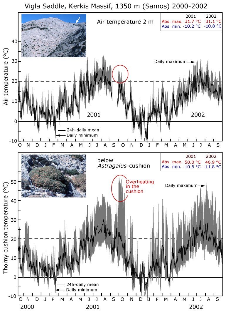
How ’bout a graph to spice it up even more… (never mind that it’s from across the sea on Kerkis.) Do you see? «overheating in the cushion» – HOT STUFF! – someone should make a (straight line) path through that thing!
(incidentally, I see Tilos has it’s very own Astragalus on flickr – but I can’t locate any photo with the tags astragalus and ikaria. – it must be just that I’m not searching properly…) 😉
angeloska
says:zzdoing!!! I am dazed -:)) Aχ Nana when you want…
(Just wait… I will edit this tomorrow morning)l
isl_gr
says:Even more dazed u should be at my friend Nana when u know that this analysis comes right out of a smoked turnery in Petrou Rali str, Athens.
filakia
Eleni

Tragopodaros says:
I lost MY map somewhere in there last year! In fact three maps I had specially copied and enlarged in Manchester; such was my struggle to hack a way through to PIGI, they fell from my pack.
Here’s another reason for the path to be cut from both ends – so that the people living at either end both feel they have a new path that TAKES them somewhere and don’t see it as an invasion from the outside world.
angeloska
says:For years hikers who stayed in Evdilos and Kampos on the coast (point A) and saw the mountains of Rahes (point C) on the west, were asking for a direct way to make it up there without having to walk on the coastal road as far as Armenistis (point B) and from there climb to Rahes (point C). At a certain point I realized that what they were asking to follow was a cut-trough on the ypotenuse of the right triangle (A-C). I like ypotenuses. They are good options to a square static world. And indeed these are the ways invaders follow.
(But of course to make a succesfull invasion, I needed an invitation and a promise for an orgy on plenty of fried good Ikarian potatoes from Perameria.)

Comments
(4 total)
Nothing to add except that «the orgy with plenty of good Ikarian potatoes from Perameria -panfried a la Belge» took place at last!
Monday September 3, 2007 – 08:34am (PDT)
- AKK
 Offline
Tuesday September 4, 2007 – 03:39pm (EEST)
«from an…» : «Βeautiful to the point of causing pain». That’s a perfect definition of a chimera -:)) I’m noting this down.p.s. «nude hiking trail»? whatever, but don’t shout it over the roofs. I don’t like «bears» -:lol:- and neither does Nana.
Wednesday September 5, 2007 – 10:54am (PDT)
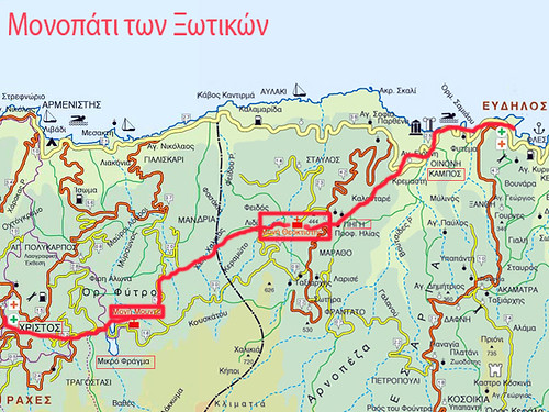
‘the trail of the elves’ – το μονοπάτι των ξωτικών (final – τελικό)
Δημοσιεύθηκε: 3 Ιουλίου, 2009 Filed under: choses vécues, exploring, hiking, ikaria, photography, pleasure, stories | Tags: angelos, ecotourism, eleni-in-ikaria, evdilos-rahes, hiking, hiking trails, ikaria, άγγελος, ικαρία, μονοπάτι των ξωτικών, μονοπάτια, map, new-trail, OPS Ikarias, self-guided hiking, trail-of-the-elves 1 σχόλιο-
Από τον Εύδηλο στις Ράχες με τα πόδια
– Μια παλιά κλασική διαδρομή ξαναγεννιέται –
Σε μια γωνιά στην κάτω πλατεία του Ευδήλου υπάρχει ένα μικρό πορτοκαλί σημαδάκι. Είναι η αρχή. Το επόμενο είναι λίγα μέτρα πιο πάνω. Κι ένα άλλο πιο πέρα. Κι ακόμα ένα. Μετά ένα βελάκι. Μετά μια πορτοκαλί πινακίδα. Κι άλλο σημαδάκι… κι άλλο βελάκι… ξανά πινακίδα… Μοιάζει με «Κυνήγι του Θησαυρού». Ναι, έτσι είναι. Υπάρχει θησαυρός. Πολυτιμότατος, μάλιστα. Μια πολύωρη, χορταστική διαδρομή με τα πόδια μέσα στη φύση και την ιστορία της βορειοδυτικής Ικαρίας.
.
.


Από τη διαδρομή μέσα στον ΕύδηλοΑπό τον Εύδηλο μέχρι τη παραλία του Κάμπου η διαδρομή είναι «περίπατος». Ακολουθώντας τη σήμανση, θα οδηγηθούμε στη συνέχεια στα «Παλάτια», δηλ. στον αρχαίο οικισμό της Οινόης. Βαδίζοντας στο «αρχαιολογικό» μονοπάτι, σκαρφαλώνουμε στο λόφο. Φτάνουμε στο «Ωδείο» και μετά περνάμε από την άλλη πλευρά, στο Μουσείο και την Αγία Ειρήνη. Τώρα ήμαστε πια στην παλιά επίσημη στράτα για τη Πέρα Μεριά.
_

__(photo by Yann!s)Η σήμανση οδηγεί στον πρώτο οικισμό, το «Κέρος» -τώρα πια μοιάζει συνοικία του Κάμπου. Κι εδώ αρχίζει η ανηφόρα. Να μην το ξεχνάμε. Πάμε για Ράχες που είναι μια ορεινή περιοχή.


Aπό τον Κάμπο για τη ΠηγήΞαφνικά στη περιοχή «Κουντουριδιά» (δηλαδή, Χαρουπιά –μεγάλο δέντρο που υπάρχει ακόμα υπάρχει εκεί) και καθώς στα πόδια μας απλώνεται ολόκληρη η κοιλάδα του Κάμπου (άραγε κάποτε ήταν λιμάνι, όπως λένε;), βρισκόμαστε να βαδίζουμε σε μια καλοκτισμένη, πολύ φαρδιά πέτρινη «ρύμη». Είναι ένα έργο πολύ εντυπωσιακό -αληθινή «λεωφόρος» για τα μέτρα της εποχής. Λένε ότι την έφτιαξαν οι εξόριστοι με το μεράκι, το πάθος και τη διάθεση προσφοράς που τους διέκρινε. Σίγουρα πρόκειται για σπάνιο μνημείο αρχιτεκτονικής που το μόνο που θέλει για να φανεί, είναι να καθαριστεί από τη βλάστηση.
Στην Κουντουριδιά η ρύμη χωρίζεται. Αριστερά πηγαίνει για Μάραθο και για Φραντάτο. Μετά συνεχίζεται για το βουνό, στο δάσος του Ράντη κι ακόμα πιο πέρα. Όμως και να θέλαμε, δεν μπορούμε να πάμε από εκεί. Λίγο πιο πάνω η ρύμη είναι φραγμένη με συρματοπλέγματα –χωρίς ποριά! Το ξεχνάμε λοιπόν και στρίβουμε δεξιά. Επιμένοντας στο αρχικό σχέδιο, πάμε για την Πηγή. Διασχίζουμε πεζούλια με κήπους, ρυάκια και στέρνες που η ρύμη αριστοτεχνικά δρασκελίζει. Θαυμάζουμε σπάνια δέντρα, παλιά σπίτια, ένα λιοτρίβι. Καταλήγουμε στο παλιό καφενείο που τώρα είναι κλειστό. Στην αυλή του απολαμβάνουμε άπλετη, υπέροχη θέα στα βουνά: Αθέρας καιΚοσκινάς.
Το μοναστήρι της Θεοκτίστης είναι το τελευταίο «φυλάκιο πολιτισμού». Εδώ όσοι κουράστηκαν, μπορούν να πάρουν το δρόμο του γυρισμού. Γιατί απ’ αυτό το σημείο και πέρα αρχίζει η πραγματική περιπέτεια. Μπροστά στον πεζοπόρο ανοίγονται πλατιές παρθένες εκτάσεις, σχεδόν ακατοίκητες, με μόνο δάση και λαγκαδιές: Φείδος, Λίδι, Χαλικιάς, Κεραμωτό, Πλατέδων. Η διαδρομή «τρυπώνει» κυριολεκτικά διασχίζοντας με ασφάλεια συναρπαστικούς αγριότοπους (wilderness) κατά μήκος μιας ζώνης που (ως εκ θαύματος) δεν έχει υποστεί τις συνέπειες της ελεύθερης, ανεξέλεγκτης βόσκησης, ούτε υπάρχουν οικοδομές που πληγώνουν το τοπίο. Βλέπει κανείς μόνο το βαθύ σκούρο πράσινο, το σκληρό γκρίζο του βράχου και στο βάθος το απαλό θαλασσί του πελάγους. Που και που κάποιος κρυμμένος παλιός οικισμός, τρία-τέσσερα σπίτια μονάχα, ερείπια πια, ίσα που φαίνονται. Ο πεζοπόρος τα βλέπει. Φαντάζεται τον τρόπο ζωής των παλαιών Ικαριωτών. Αυτό γίνεται «επί ίσοις όροις». Όπως αυτός, έτσι κι εκείνοι δεν είχαν αυτοκίνητα. Βασίζονταν μόνο στα πόδια τους.


Έτσι πηγαίνουμε μέχρι να συναντήσουμε το χωριό «Λαψαχάδες» στις Ράχες. Από εκεί και μετά η διαδρομή ακολουθεί για πολλή ώρα έναν αγροτικό χωματόδρομο. Θα μας βγάλει στις παρυφές του φαραγγιού «Μύρσωνας» απέναντι από το χωριό «Άγιος Πολύκαρπος». Ο Μύρσωνας είναι το ποτάμι που καταλήγει στη Μεσαχτή. Εδώ πια έχουμε μπει στο δίκτυο των σηματοδοτημένων διαδρομών που έχουν αποτυπωθεί στο χάρτη «Γύρος των Ραχών με τα Πόδια» (έκδοση 2005). Αν έχουμε βαρεθεί το βουνό, παίρνουμε το «Μονοπάτι του Μύρσωνα» και μετά από δυο ώρες περίπου θα κάνουμε μπάνιο στη Μεσαχτή. Αν όμως όχι, στρίβουμε αριστερά και τραβάμε για τη Μονή Ευαγγελίστριας Μουντέ. Από εκεί –είτε απ’ τον δρόμο, είτε απ’ το «μονοπάτι με τις πατούσες»- ο Χριστός Ραχών απέχει μια ώρα περίπου. Είναι το τέρμα της διαδρομής. Αν σας πήρε λιγότερο από 7 ώρες για να την κάνετε, τότε ήσαστε έμπειρος οδοιπόρος με καλή φυσική κατάσταση και αντοχή. Συγχαρητήρια!
«Μονοπάτι των δύο μοναστηριών», «Μονοπάτι των Εξορίστων» και «Μονοπάτι των Ξωτικών», ονόμασαν αυτή τη πορεία διάφοροι πεζοπόροι, ξένοι κυρίως, που για πολλά χρόνια προσπαθούσαν να ανακαλύψουν. Εδώ κι εκεί διάφοροι σωροί από πέτρες και μισοσβησμένα σημαδάκια με χρώμα μαρτυρούν αυτές τις απόπειρες. Το κίνητρο τους ήταν πολύ λογικό. Αφού ο παραλιακός δρόμος Εύδηλος- Ράχες είναι σχετικά πρόσφατο έργο, ποια ήταν η παλιά «ημιονική οδός» μέσα από τα βουνά; Από ποιο δρόμο κατέβαιναν οι μαθητές των Ραχών για να πάνε στο Γυμνάσιο στον Εύδηλο;


Εκείνη η παλιά παραδοσιακή διαδρομή ξαναβρέθηκε κι ανοίχτηκε πάλι. Η αναζήτηση κράτησε ένα χρόνο περίπου. Άλλον ένα χρόνο κράτησε ο καθαρισμός (πριόνι, κλαδευτήρι), συν κάποιους μήνες για να γίνει η σηματοδότηση. Ίσως δεν είναι ακριβώς η «αυθεντική» παλιά διαδρομή, αφού σε πολλά σημεία πέρασαν από πάνω της δρόμοι και άλλα έκλεισαν και χάθηκαν μέσα στη βλάστηση. Έχοντας βρει διάφορα πλαϊνά μονοπάτια, έγινε ωστόσο μια αρκετά πιστή «προσομοίωση». Έχει μήκος πάνω από 15 χιλιόμετρα, όμως σε γενικές γραμμές δεν είναι δύσκολη διαδρομή. Το έδαφος είναι ομαλό χωρίς κουραστικές ανηφόρες, υπάρχουν πολλά νερά και τα δάση προσφέρουν πλούσια σκιά.
 Αυτός είναι ο Γύρος των Ραχών με τα Πόδια -2005.
Κάντε κλικ εδώ για να δείτε ένα πρόχειρο χάρτη της νέας διαδρομής Εύδηλος-Ράχες.Μαζί με άλλες διαδρομές που ανοίχτηκαν πρόσφατα, η διαδρομή Εύδηλος-Ράχες θα περιλαμβάνεται στον χάρτη του αυτοχρηματοδοτούμενου οικοτουριστικού προγράμματος «Γύρος των Ραχών με τα Πόδια», το οποίο φυσικά στο εξής δεν θα λέγεται έτσι. Παρουσιάζοντας ανοιχτές, σηματοδοτημένες διαδρομές από τον Εύδηλο μέχρι το Καρκινάγρι, ο νέος χάρτης θα φέρει τον τίτλο «Οδοιπορικές Διαδρομές στη Δυτική Ικαρία».
Να ‘μαστε καλά, να τις κάνουμε όλες.

Άγγελος Καλοκαιρινός
(φωτ. Ελένη Ικάνου, δικές μου και άλλων φίλων)
Ιούνιος 2007
Comments
(8 total)
Τρελαινομαι να κανω χατηρια στον Αγγελο! Μου το στειλε και το ανεβασα. Το θελουν λεει για να το τυπωσουν στο περιοδικακι του Δημου Ευδηλου, «Ευδηλα Νεα». Ελπιζω να μπει κι ετσι αυτη η απιστευτη δουλεια να γινει γνωστη. Αργοτερα θα γράψω κι εγω τη δικη μου εκδοχη. Some time later I will write my own version of this hiking route in English. I will let free myself to be very personal -wildly subjective, utterly mad! This unbelievable hike calls for such attitude. After all it was me who discovered it!
Sunday June 10, 2007 – 12:30pm (PDT)
Θέλει μόνο να έχει μια λίμνη κάπου στη μέση της διαδρομής για να κάνουμε βουτιές για φρεσκάρισμα. Να πάρουμε το γάδαρο και τσιμέντα και να πάμε να φτιάξουμε μία; Ιδρώνεις πολύ σ’ αυτή τη διαδρομή. Εγώ πηγαίνω γρήγορα και πάντα βρίσκω νερό και ξεφουντώνω. Οι άλλοι όμως;

Tuesday June 12, 2007 – 12:11pm (EEST)
Ελένη : ❤
Νανά : χωρίς ρούχα !! 🙄
Tuesday June 12, 2007 – 10:41pm (EEST)
Δεν είναι τουριστική φάση αυτά τα πράγματα. Πάμε λίγο πιο μπροστά, αλλά κατά βάση δουλεύουμε με τη «κοινότητα». Άμα η κοινότητα δεν θέλει, δεν γίνεται και δεν πρέπει να γίνεται τίποτα. Όμως η Ικαρία (σαν κοινότητα -ιδίως οι νέοι) άμα ξέρει και θέλει, μπορεί να κάνει τεράστια βήματα. Ακόμα και να κάνει το χατήρι της Νανάς 😉
Wednesday June 13, 2007 – 12:43pm (PDT)
Είχα σκεφτεί κάτι να πω. Αλλά τι να πω; Τα ‘πες όλα, Ελένη…
Thursday June 14, 2007 – 10:40am (EEST)
Ναι ηταν μια στιγμη μεγαλης εμπνευσης
Monday June 18, 2007 – 12:36pm (PDT)
- Yann!s
- Offline
Εχω πάει στην Ικαρία 3-4 φορές. Πάντα κολάω στα παράλια. Αλλά μία τουλάχιστον βόλτα θα ήθελα να την κάνω. Ν’ ακολουθήσω αυτά τα σημάδια και όπου με βγάλουν. Μετά όμως θα πάω να ξαναβαφτιστώ στα αγαπημένα μου νερά. Ευχαριστώ Λενιώ, Αγγελε χάρηκα που σας γνώρισα κι από κοντά.
Monday October 8, 2007 – 03:07am (EEST)
Αυτα τα σημαδια θα σε βγαλουν ξανα πισω… στη θαλασσα!
Αυτη ειναι η μαγεια σε ενα βουνο στη μεση του αιγαιου. Εκτιμας τη θαλασσα καλυτερα ετσι!

Saturday October 13, 2007 – 12:52pm (PDT)
Hiking like Flying
Δημοσιεύθηκε: 2 Ιουλίου, 2009 Filed under: choses vécues, exploring, flying, hiking, ikaria, stories | Tags: aegean, agrimi-mou, angelos, ecotourism, good-conspiracy, hiking, hiking trails, ikaria, island in the aegean sea, άγγελος, αγρίμι-μου, ελληνικά-entries, ικαρία, μονοπάτια, map, my-friends, natura2000, new-trail, trail-of-the-elves ΣχολιάστεΓια την Ικαρία βρίσκω πάντα 5 λεπτά καιρό για ένα γρήγορο copy-paste. Το παρακάτω τα έγραψε ο Άγγελος για να απαντήσει σε ερώτηση της Νανάς στο φόρουμ του ιντερνετικού κλαμπ των οδοιπόρων της Ικαρίας. Όμως κάτι έγινε με τα Greekfontsκαι ίσως κάποιοι ενδιαφερόμενοι δεν μπόρεσαν να διαβάσουν κανένα από τα δυο μηνύματα. Εγώ τα πήρα και τα δύο σωστά στο mailμου κι έτσι τα αναπαράγω εδώ.
______________________________________________________
Λοιπόν η Νανά είχε γράψει:
______________________________________________________
Γειααα…
The Round of Rahes has expanded. Is the map outdated now? Except the «trail of the elves» (Evdilos – Rahes) which other trails have you made sure to find and follow? Can you announce? What other ways across wildernesses and «lost villages» are we to expect? What about the southern side?
There is a thought that we come and help you in June. Me together with Doubting Thomas, if you don’t mind. He asks to know everything beforehand.
Any progress in finding out who the unknown cairn-makers are? Should we think of this as just another mystery of Ikaria?
Nan
http://egotoagrimi.wordpress.com
>>>>>>>>>>>>>>>>>>>>>>>>>>>>
Είναι φανερό πως ο Γύρος των Ραχών έχει επεκταθεί. Ο χάρτης είναι λοιπόν ξεπερασμένος; Εκτός από «το μονοπάτι των ξωτικών» (Ράχες – Εύδηλος) ποιά άλλα μονοπάτια έχεις σιγουρέψει; Μπορεί να ανακοινώσεις; Τι άλλες διαδρομές μέσα από αγριότοπους και «χαμένα χωριά» να περιμένουμε; Τι γίνεται με τη νότια ακτή;
Γίνεται μια σκέψη να ‘ρθουμε και να σε βοηθήσουμε τον Ιούνη. Εγώ μαζί κι ο Άπιστος Θωμάς, αν δεν σε πειράζει. Όμως θέλει να τα ξέρει όλα προκαταβολικά.
Έχουμε κάποια εξέλιξη στο να βρεθούν ποιοί είναι οι άγνωστοι κτίστες των «κούκων»; Άλλο ένα μυστήριο της Ικαρίας αυτό;
Ναν
http://egotoagrimi.wordpress.com
______________________________________________________
Κι η απάντηση του Άγγελου ήταν:
______________________________________________________
This is about the new trails. An English translation will be coming soon…
Αυτήν τη στιγμή οι νέες πεζοπορικές διαδρομές, προεκτάσεις του «Γύρου των Ραχών», είναι:
1) Ράχες (Μονή Μουντέ) – Περαμεριά (μονή Θεοκτίστης στο χωριό Πηγή) – Κάμπος (και Εύδηλος). 24 χιλ. περίπου. Κινείται σε μέσο υψόμετρο 400 μ. σε μήκος 24 χιλιομέτρων περίπου κατά μήκος μιας παρθένας ζώνης με πευκώνες, μακία και «χαμένα χωριά», η οποία έχει παραμένει ανεπηρέαστη τόσο από τη βόσκηση (που συμβαίνει πιο ψηλά στο βουνό), όσο και από την οικοδόμηση (που συμβαίνει πιο χαμηλά στα παράλια). Γι’ αυτό σωστά ονομάστηκε (ευχαριστώ!) «μονοπάτι των ξωτικών». Δεν έχω περπατήσει ακόμα ολόκληρη τη διαδρομή μονομιάς, όμως υπολογίζω ότι από την πλατεία του Ευδήλου μέχρι την πλατεία του Χριστού στις Ράχες πρέπει να είναι γύρω στις 7-8 ώρες άνετο περπάτημα με πολλές στάσεις. Ανήφορος υπάρχει μόνο ένας, από τον Κάμπο στην Πηγή, που είναι όμως λιθόστρωτος «ντουσεμές», εύκολος στο περπάτημα και με θαυμάσια θέα.
2) Ράχες (μικρό φράγμα στις Καστανιές) – Πούντα (Άγιος Δημήτριος). Στην αρχή της διαδρομής (λίγο πριν τις λίμνες) η πινακίδα γράφει «Άγιος Κήρυκος 8 ώρες». Αυτό το μονοπάτι είναι ο παλιός δρόμος από τις Ράχες για την πρωτεύουσα του νησιού. Μέχρι τώρα το ήξεραν ελάχιστοι πεζοπόροι. Αυτός όμως είναι ο πιο σύντομος δρόμος από και προς Άγιο Κήρυκο. Ανεβαίνοντας τον Μύρσωνα και αφήνοντας δεξιά κι αποφεύγοντας τα οροπέδια «Αμμούδια» και «Ζηζόκαμπος», το μονοπάτι οδηγεί κατευθείαν στις εκτάσεις πάνω από το Φραντάτο. Το σκηνικό είναι γεμάτο άγριο μυστήριο. Αδύνατο να πιστέψει κανείς ότι κάποτε ήταν μια εξαιρετικά πολυσύχναστη διαδρομή. Αυτή είναι επίσης η αμεσότερη οδός από τις Ράχες για το Δάσος του Ράντη.
3) Έχει γίνει μια πρώτη σήμανση στη διαδρομή από Προεσπέρα προς Κουνιάδο, Βρακάδες, Λαγκάδα (και μετά Άγιο Ισίδωρο, Καρκινάγρι ή Τραπάλου). Δεν ασχολούμαι πολύ μ’ αυτό γιατί δεν προλαβαίνω, αλλά κι επειδή το μεγαλύτερο μέρος της (Προεσπέρα – Βρακάδες) είναι δρόμος αμαξιτός. Απλά υπάρχουν κάποιες ενδείξεις. Άλλωστε αυτή η μακριά διαδρομή υπάρχει στον χάρτη μονοπατιών του Τουριστικού Οδηγού του Δήμου Ραχών ο οποίος επανεκδίδεται σύντομα.

Το μεγάλο προσόν αυτής της διαδρομής είναι η άπλετη θέα στο Αιγαίο. Νομίζεις ότι πετάς.
4) Θέλω να τονίσω (κυριολεκτικά, να υμνήσω) τους άγνωστους κατασκευαστές των σωρών από πέτρες, γιατί κτίζοντας «κούκους» προτείνουν μια νέα διαδρομή : Νας – Ελιάς Κάμπος (!) Αυτήν τη στιγμή, ένας σκληραγωγημένος οδοιπόρος που θα ξεκινήσει από το Να κι αφού έχει ανέβει ολόκληρο (!) το Φαράγγι της Χάλαρης και πιο πάνω (!) μέχρι το οροπέδιο «Εριφή», μπορεί μετά (ακολουθώντας τους «κούκους») να κατέβει στον ορμίσκο «Ελιάς Κάμπος» (ανατολικά του Τραπάλου). Είναι μια διαδρομή τουλάχιστον 10 ωρών, σηματοδοτημένη με όμορφους σωρούς από πέτρες κάθε 50-100 μέτρα !
5) Υπάρχουν κι άλλες πολλές επί μέρους που δεν αναφέρω εδώ. Εν κατακλείδι, τα πορτοκαλί σημάδια («πατούσες» ή βούλες) πάνε παντού! Αγοράζετε, διαδίδετε τον χάρτη «Γύρος των Ραχών με τα Πόδια». Αυτός «πληρώνει» για όλα αυτά. Κυρίως «πληρώνει ηθικά», αν με πιάνετε…
ανκοκα
P.S. English translation coming soon…
_______________________________________
Καλή ευκαιρία να πω ότι μέσα στον χαμό με το μωρό, τη δουλειά, την έλλειψη ύπνου και φαγητού, ξαφνικά κάτι έκανε κλικ και … άρχισα να γράφω καλή Ελληνική ορθογραφία και στίξη και ΤΟΝΟΥΣ !!!!
(Θα σας τα πω σε άλλο blogentry, άραγε να δούμε πότε…)
y.γ. η Νανούλα το αγρίμι που προσέχει το blog μου, όταν μπορέσει, θα έρθει να κανει edit entry και να βαλει κι άλλα διάφορα links πίσω απ’ το κειμενο.
.


.
Comments
(2 total)
Thursday March 15, 2007 – 11:13pm (EET)
You say that now the unknown cairn-makers have marked with beautiful made cairns the entire distance from Nas on the North coast and across the plateau Erifi on the mountain to Elias Kampos on the South. So we have a total new hiking itinerary. (1, 2, or 3 days?) Great idea, great plan and a great job “on the field” too! But why have they done it incognito? I gave some thought on the reason. Maybe..
Friday March 16, 2007 – 12:40pm (EET)
ΣΤΑ ΜΟΝΟΠΑΤΙΑ ΤΗΣ ΙΚΑΡΙΑΣ
Δημοσιεύθηκε: 1 Ιουλίου, 2009 Filed under: choses vécues, exploring, hiking, ikaria, stories, travel, Uncategorized | Tags: adventure, aegean, angelos, ecotourism, enviro-lore, Greece, greek-entries, hiking, hiking trails, ikaria, interview, island life, συνέντευξη, Ορειβατικός Πεζοπορικός Σύλλογος Ικαρίας, ΟΠΣ Ικαρίας, άγγελος, ελληνικά-entries, ικαρία, μονοπάτια, links, my-friends, OPS Ikarias, trail-of-the-elves, what-it-takes 7 Σχόλια
UPDATE 30/11/2023 ❤
– Η σηματοδότηση μονοπατιών αποτελεί προσωπικό όραμα ή συλλογική επιθυμία;
– Να σηματοδοτεί κανείς και να σχεδιάζει διαδρομές σε ένα νησί όπως η Ικαρία δεν μπορεί παρά να ξεκινά από ένα προσωπικό όραμα. Δεν προέκυψε από κάποιο γεγονός, ας πούμε, ότι οι κάτοικοι είναι ιδιαίτερα δραστήριοι ή ευαίσθητοι στο θέμα τουρισμός.


Αγαπούν βέβαια πάρα πολύ τον τόπο τους, πράγμα που είναι πάρα πολύ σπουδαίο, όμως αυτό δεν αρκεί. Για να υπάρξει συλλογική δράση -προς οποιαδήποτε κατεύθυνση- δεν φτάνει η αγάπη. Χρειάζεται να εμβαθύνει κανείς στη φυσιογνωμία του τόπου, να νιώσει τις ανάγκες, τις ευκαιρίες και τις δυνατότητες. Είναι επίσης πολύ σπουδαίο να μένει κανείς στην Ικαρία και το χειμώνα. Κι αυτό είναι το πιο δύσκολο κατά τη γνώμη μου. Για παράδειγμα, υπάρχουν πάρα πολλοί σύλλογοι Ικαριωτών με αξιόλογους και μορφωμένους ανθρώπους που ενδιαφέρονται για τον οικοτουρισμό, τη φύση, τη προστασία του περιβάλλοντος ή την ορειβασία. Όμως οι Σύλλογοι αυτοί έχουν έδρα στην Αθήνα. Ακόμα και πολλοί Ικαριώτες ξενοδόχοι που υποτίθεται έχουν άμεσο συμφέρον από τέτοιες πρωτοβουλίες, περνούν τον χειμώνα στην Αθήνα. Ενώ οι συνάδελφοι τους στα γειτονικά νησιά μένουν το χειμώνα και οργανώνουν συλλογικά διάφορες εκστρατείες: καθαρίζουν τις παραλίες, μαζεύουν τα σκουπίδια απ’ τους δρόμους, φυτεύουν δέντρα, καθαρίζουν και σηματοδοτούν μονοπάτια.
– Ποιό είναι λοιπόν αυτό το προσωπικό όραμα;
– Κατ’ αρχήν να το ξεκαθαρίσω: ότι οι Ικαριώτικοι σύλλογοι ή οι ξενοδόχοι δεν βγαίνουν να σηματοδοτήσουν, ή να χρηματοδοτήσουν κάτι σχετικό με τον οικοτουρισμό στο νησί, δεν σημαίνει ότι δεν παρέχουν σημαντική ηθική υποστήριξη. Τα μονοπάτια είναι «δημόσιος χώρος» και σαν κάθε δημόσιος χώρος χρειάζεται προστασία. Τυπικά αρμόδιοι είναι οι Δήμοι, όμως όσο περισσότεροι άνθρωποι βγαίνουν και λένε ότι τα μονοπάτια χρειάζονται (ως κληρονομιά του παρελθόντος και ως αξία του σήμερα) δύσκολα τολμάει κάποιος να κλείσει ή να καταστρέψει ένα μονοπάτι. Ενώ παλιά έλεγαν, «Έλα μωρέ. Αυτό ήταν παλιά τότε που πήγαιναν με τα μουλάρια. Τώρα ας πάνε από τον δρόμο«. Αυτό έπρεπε να το τονίσω για τους συλλόγους, ιδιαίτερα γι’ αυτούς από την περιοχή μου. Όσο για το προσωπικό όραμα και πως ξεκίνησε, είναι μεγάλη κουβέντα.
– Έχουμε χρόνο και χώρο. Στο blog της Ελένης ήμαστε…
– Θα το πω όσο γίνεται πιο απλά. Εγώ την Ικαρία την ήξερα από τον Αρμενιστή. Ο πατέρας μου ήταν εκπαιδευτικός κι έτσι κάναμε μεγάλες διακοπές εκεί τα καλοκαίρια. Αγαπούσα τη θάλασσα, όμως πολύ συχνά ανέβαζε μελτέμι και είχε φουρτούνα. Έτσι άρχισα να εξερευνώ το εσωτερικό του νησιού με τα πόδια.

![]()
![]()
Χρόνο με τον χρόνο έμενα κατάπληκτος με το πλούτο της φύσης και της παράδοσης. Επίσης υπήρχε μια αίσθηση ελευθερίας και άνεσης που με συνάρπαζε, μαζί και κάτι το μυστηριώδες που προκαλούσε για εξερεύνηση.


Αργότερα ταξίδεψα πολύ στην Ελλάδα και στο εξωτερικό. Εκεί όμως που πρωτοσκέφτηκα το θέμα «μονοπάτια» ήταν στο Άγιο Όρος. Αυτό ήταν πολύ παλιά όταν δεν υπήρχαν δρόμοι και αυτοκίνητα. Ο πρώτος χάρτης μονοπατιών που είδα ποτέ ήταν του Άθωνα. Μου έκανε μεγάλη εντύπωση εκείνος ο χάρτης. Αλλά πιο μεγάλη εντύπωση μου έκανε η ομοιότητα του τοπίου του Άθωνα με την Ικαρία.


Συζητώντας γι’ αυτά με ένα ηγούμενο μοναστηριού, μου είπε το εξής:
«Αυτό που βλέπεις με τα μοναστήρια, το βουνό, τα δάση και τα μονοπάτια, δεν άπεχει πολύ από την εικόνα της Ελλάδας πριν το αυτοκίνητο. Αν βάλουμε στην άκρη τον θρησκευτικό παράγοντα, αυτό είναι που γοητεύει τους επισκέπτες. Όπως είναι τώρα τα μοναστήρια και οι σκήτες, έτσι ήταν παλιά τα χωριά και οι οικισμοί στην Ελλάδα.»
Τότε μου ήρθε πρώτη φορά η σκέψη να γίνουν μονοπάτια στην Ικαρία. Θα ήταν ένα δίκτυο με σηματοδότηση, πινακιδούλες και διασταυρώσεις, ακριβώς όπως το είδα στο Άγιο Όρος.
– Είναι πολλοί όσοι χρησιμοποιούν τα μονοπάτια;
– Δεν έχω στατιστικές, όμως κρίνοντας από τις πωλήσεις του χάρτη των μονοπατιών, φαίνεται πως είναι αρκετοί. Βλέπω επίσης τα ίχνη τους στις διαδρομές. Οι διαδρομές φαίνονται «χρησιμοποιημένες» -πατημένες- κι αυτό με χαροποιεί ιδιαίτερα.

")

Μερικές φορές με πιάνει άγχος και σκέφτομαι πως πρέπει να γίνει τούτο ή το άλλο, πως πρέπει να βρεθούν πόροι, υποστήριξη, βοηθοί κτλ. και να γίνουν έργα στο μονοπάτια, όμως μετά ηρεμώ.

Σκέφτομαι πως στην Ικαρία με τόσα προβλήματα στις υποδομές, στους δρόμους και τόσα άλλα, ούτε για τις παραλίες δεν μπορεί να υπάρξει σωστή μέριμνα. Πόσο λιγότερο να γίνουν επενδύσεις για τον οικοτουρισμό. Αυτό είναι πολυτέλεια προς το παρόν.
– Ποιοί άνθρωποι περπατούν στα μονοπάτια;
– Αν και η Ικαρία προσφέρεται για κανονικούς ορειβάτες, αυτοί που περπατούν στα μονοπάτια είναι κάθε είδους άνθρωποι. Απλοί τουρίστες που κάθονται στην παραλία μπορεί ξαφνικά να βαρεθούν και να αρχίσουν να περπατούν στο εσωτερικό. Ιδίως οι ξένοι που έχουν τέτοια κουλτούρα. Γι’ αυτούς διακοπές σημαίνει αποφυγή των μετακινήσεων με αυτοκίνητο και όσο το δυνατόν πιο άμεση επαφή με τη φύση.


Καθόλου δεν το σκέφτονται σαν ορειβατική εμπειρία. Εξάλλου όσο κι αν σε ορισμένα σημεία οι διαδρομές είναι δύσκολες, οι αποστάσεις είναι μικρές, ενώ η οπτική επαφή με τη θάλασσα και το λαμπρό φως του Αιγαίου βοηθούν πάρα πολύ…


– Ότι δεν θα μας φάνε οι λύκοι κι οι αρκούδες;
– Ναι, αυτό ακριβώς… (γέλια)
– Η σηματοδότηση των μονοπατιών ξεκίνησε με κάποια ευρωπαϊκά προγράμματα ή ανεξάρτητα από αυτά;
– Ξεκίνησε από μια σειρά αγαθών συμπτώσεων τις οποίες είχα την ετοιμότητα και τον χρόνο να εκμεταλλευτώ. Αλλά κι αυτό έγινε από σύμπτωση. Καμία σχέση δεν είχε με ευρωπαϊκά προγράμματα. Πολλοί στην αρχή νόμιζαν πως αυτό ήταν το κίνητρο. Τόσο παράξενο φάνηκε ότι οι τουρίστες ξαφνικά «θα πάρουν τα βουνά«. Παραξενεύτηκαν επίσης λόγω του ότι δεν γνώριζαν ή δεν εκτιμούσαν αρκετά την αξία του εσωτερικού του νησιού. Σε κάθε περίπτωση, ο λόγος που απέφυγα τα ευρωπαϊκά προγράμματα ήταν ο εφιαλτικά γραφειοκρατικός χαρακτήρας τους. Χρειάζονταν τόσα πολλά χαρτιά και υπογραφές, διασυνδέσεις και αλληλογραφία, ώστε όφειλε κανείς να ασχοληθεί επαγγελματικά με το θέμα. Έτσι ή θα φτιάχναμε μονοπάτια ή θα γεμίζαμε φακέλους με χαρτιά. Προτίμησα το πρώτο. Στην πορεία βρέθηκε λύση για τη χρηματοδότηση -αποζημίωση θα την έλεγα καλύτερα. Με την υποστήριξη συλλόγων από την περιοχή εκδόθηκε ένας ωραίος χάρτης και από τις πωλήσεις του βγαίνουν κάποια έξοδα. Είναι συμβολικό μάλλον, αλλά εμένα αυτό μου αρκεί.


– Ναι αλλά αφορά μόνο τις Ράχες και τη δυτική Ικαρία. Πως θα γίνει το πρόγραμμα να επεκταθεί;
– Θα το ήθελα πολύ, αλλά ειλικρινά δεν ξέρω πως θα γίνει. Ο λεγόμενος ήπιος φυσιολατρικός τουρισμός πάει καλά στην Ικαρία -και μάλιστα αυτό γίνεται «από στόμα σε στόμα», ανεξάρτητα από γραφεία και τουρ οπερέιτορς. Δεν πάει άλλο να σφυρίζουμε αδιάφορα και να βλέπουμε αυτό το φαινόμενο όπως π.χ. βλέπουμε τη βροχή -πότε έρχεται και πότε δεν έρχεται, ε τι να κάνουμε. Χρειάζεται δουλειά. Μια καλή ιδέα εδώ, ένα απαραίτητο μικρό έργο εκεί. Μια μικρή, αλλά διαρκής κι αδιάκοπη φροντίδα παντού. Αυτά δίνουν μεγάλες «επιστροφές» κι ανταμείβουν τους κόπους. Για να το πω χύμα: μια σωστή πινακίδα στο σωστό σημείο, μπορεί και κρατά κόσμο στο νησί για περισσότερες μέρες. Αν πέτυχε «Ο Γύρος των Ραχών με τα Πόδια» ο κυριότερος λόγος ήταν η μανία μου με τη σηματοδότηση. Όμως αυτό δεν μπορώ να το κάνω μόνος μου για πολύ καιρό. Ιδιαίτερα όταν οι απόστασεις είναι πολύ μακρινές από εκεί που μένω.


Το να ανοίγω και να σηματοδοτώ ενδιαφέρουσες διαδρομές είναι κάτι που θέλω και μου αρέσει. Κανείς δεν με υποχρεώνει να το κάνω. Όμως από τη στιγμή που θα το κάνω, νιώθω υποχρεωμένος να συντηρώ αυτή τη διαδρομή. Να την ελέγχω μην πάει κάποιος και την κλείσει, να κόβω τους θάμνους, να ξαναπερνάω τα σημάδια κτλ. Αυτό γίνεται όλο και πιο δύσκολο όσο απέχει η διαδρομή από το σπίτι μου. Τότε μιλάμε για πραγματικά μεροκάματα συνέχεια όλο το χρόνο.
– Ωστόσο, δεν θα ήταν ευχής έργο να έβγαινε κάποτε «Ο Γύρος Όλης της Ικαρίας με τα Πόδια»;
– Κοίτα, τώρα τελευταία έχουν φτιαχτεί κάποιες παρέες ντόπιοι που περπατούν και στις τρεις περιοχές της Ικαρίας -Ράχες, Εύδηλο και Άγιο Κήρυκο. Πολλοί ανάμεσά τους είναι νέοι και μένουν μόνιμα στο νησί. Φαίνεται πως θα τους γίνει συνήθεια. Ίσως να μπορούσαμε να συνεννοηθούμε. Θα φτιάχναμε τότε ένα δίκτυο διαδρομών και θα έβγαινε ο σχετικός χάρτης. Μετά όμως εκείνοι θα έπρεπε να προσέχουν τις διαδρομές και να τις συντηρούν.


Από τις πωλήσεις του χάρτη θα έβγαιναν δυο-τρία καλά τραπεζώματα και κρασοκατανύξεις για την παρέα. Ίσως θα μπορούσαμε να οργανώνουμε και χοροεσπερίδες … (γέλια)
– Δεν ελπίζεις τίποτα από αυτούς που δραστηριοποιούνται επαγγελματικά με τον τουρισμό;
– Ελπίζω να παρέχουν καλές υπηρεσίες στον τομέα τους, είτε ξενοδοχείο είναι αυτό, είτε εστιατόριο ή ό,τι άλλο. Αυτό είναι όλο. Πιστεύω ότι ο καθένας πρέπει να είναι καλός στον τομέα του. Έτσι βγαίνει καλό το σύνολο. Μερικοί κάνουν κάποιες καλές προσπάθειες στη διαφήμιση /ενημέρωση κυρίως μέσα από το διαδίκτυο.

Και αυτό είναι καλό. Όμως δεν αρκεί, αν δεν υπάρχουν έργα.
Αν διαφημίζεις κάτι που δεν υπάρχει ή που δεν μπορείς να δεις ή να το κάνεις, η διαφήμιση καταλήγει να είναι παραπλάνηση. Χρειάζεται δουλειά «στο πεδίο».
Έτσι λένε όσοι ξέρουν. Καλός ο υπολογιστής και το ίντερνετ, αλλά πρέπει να λερώσουμε λίγο και τα χέρια μας.


– Σχέδια για το μέλλον;
– Μου είναι αδύνατον να διανοηθώ την Ικαρία ως πεδίο άναρχης δόμησης με παντού μισοτελειωμένες οικοδομές και σπίτια άδεια που κατοικούνται 1-2 βδομάδες το καλοκαίρι. Δεν μπορώ να φανταστώ πως δεν βρίσκουμε άλλο τρόπο να επενδύσουμε τα λίγα χρήματα μας παρά στο τσιμέντο. Το ίδιο αδύνατον μου είναι να την φανταστώ σαν χώρο εναπόθεσης -πάρκινγκ- αδέσποτων κατσικιών.


Πάρτε μια τυχαία ομάδα ανθρώπων από οπουδήποτε στον κόσμο. Το σίγουρο είναι ότι, όχι όλοι, όμως το 2% από αυτούς να αναγαλλιάσει γνωρίζοντας το τοπίο του νησιού. Αν το καλοσκεφτείς, αυτό το 2% δεν είναι καθόλου λίγο. Και μάλιστα είναι ένα ποσοστό σταθερό. Είναι οι άνθρωποι που πιστεύουν σε δύο πολύ σπουδαίες βασικές αξίες: φύση και ελευθερία. Αυτοί ποτέ δεν χάνονται. Πάντα τους ξαναβρίσκει κανείς σε όλους τους τόπους και τις εποχές.

– Κάποιο σχέδιο πιο συγκεκριμμένο;
– Πολύ πρόσφατα αγόρασα ένα πολύ πρακτικό βενζινοκίνητο αλυσσοπρίονο τόσο μικρό που είναι σαν παιχνίδι. Με αυτό το εργαλείο και με τη βοήθεια της 10χρονης κόρης μου που είναι καλή να ζωγραφίζει χρωματιστές τελείες με το πινέλο στα βράχια, θα προεκτείνουμε τον «Γύρο» μέχρι τον Εύδηλο. Αυτό θα είναι το μονοπάτι «των δύο μοναστηριών» -Μουντέ και Θεοκτίστης.


Είναι μια πολύ μεγάλη, αληθινά μαγική διαδρομή και ξέρω ότι θα έχει μεγάλη επιτυχία. Όμως δεν ξέρω αν θα προλαβαίνω να την συντηρώ. Ελπίζω να υπάρξει βοήθεια από τη μεριά του Ευδήλου. Στην Ικαρία βρίσκομαι.


Αποκλείεται να είμαι ο μόνος τρελός… (γέλια) Σίγουρα υπάρχουν κι άλλοι … (γέλια)
………………………………………………..
(Αφορμή και έμπνευση γι’ αυτήν τη συνέντευξη στάθηκε μια αντίστοιχη συνέντευξη ενός πολύ συμπαθητικού τύπου, «υπεύθυνου μονοπατιών» του Ταϋγέτου που διαβάσαμε σχεδόν ταυτόχρονα εγώ και ο Άγγελος στο τελευταίο τεύχος του περιοδικού «Ανεβαίνοντας«. Μιλήσαμε στο τηλέφωνο και είπαμε να κάνουμε το ίδιο πράγμα. Βγήκε πολύ εύκολα. Τώρα σκέφτομαι να πάρω συνέντευξη και από την Ελένη. Έχει πολλά να πει, όμως δεν ξέρω πως να την παρουσιάσω. «35χρονη πεζοπόρος«; «Μια κολητή μου«; Τέλος πάντων. Μην ανησυχείτε. Κάτι θα βρω.)

Αθηνά Σκ.
Comments
(4 total)
Βρε Νανά, βλέπω σκαλίζεις τα παλιά αρχεία του http://groups.yahoo.com/group/hikingIkaria_Archives/. Δεν ξέρω τι θα έκανα στη Σαχάρα, αλλά στην Ικαρία μου φαίνεται αστείο να χρησιμοποιώ δορυφορική πλοήγηση. Η παρατήρηση με το μάτι είναι πολύ πιο σπουδαία. Όχι βέβαια πως θα με χάλαγε να με ακολουθούσε κάποιος με ένα GPS -αρκεί να ήταν ένα όμορφο αγρίμι σαν κι εσένα που επιπροσθέτως ξέρεις να δουλεύεις όλα τα μυστήρια μηχανάκια.
Friday January 5, 2007 – 01:24pm (EET)
Πρόσθεσα τα λινκς που μου πρότεινες και παραπέμπουν σε φωτογραφίες. (Ελπίζω να τις έβαλα σωστά). Τώρα είναι σαν κανονικό άρθρο σε περιοδικό. Θα χρησιμοποιήσω το ID της Ελένης και θα το ανακοινώσω special notice στο hikingIkaria. Δεν δέχομαι αντιρρήσεις. Τα μονοπάτια στην Ικαρία είναι ότι πιο σπουδαίο, όσο σπουδαία είναι τα πανηγύρια και η Μεσαχτή, κατά τη γνώμη μου.
(μακάρι να σε βοηθούσα βρε, αλλά τώρα έχουμε baby-sitting. Έχει κι άλλα αγρίμια. GPS τώρα έχουν και τα κινητά τηλέφωνα.)
Sunday January 7, 2007 – 03:06pm (EET)
Τhank you for the she-elf / Ευχαριστώ για τη «ξωθιά» (Κρητικό ιδίωμα, Νανά 😉


As a «child-explorer» I have seen many. Z was the best and thanks for recovering her photos. Όλα για τις γυναίκες τα κάνουμε γαμώτο. Μικρές – μεγάλες.
Thursday January 18, 2007 – 11:26pm (EET)
X-plorers and F-airies : that can make a very good RPG (role-play game). The nature of Ikaria is very fit…
Friday January 19, 2007 – 12:55pm (PST)
No Nature without Culture
Δημοσιεύθηκε: 29 Ιουνίου, 2009 Filed under: choses vécues, exploring, hiking, ikaria, photography, stories | Tags: 2-ophelias, cascades, Cézanne, Chalares, enviro-lore, girl, greeks-in-crisis, gruvaloi, hiking, ikaria, ikarian-enigma, Χάλαρη, αγγελολιβάδα, ικ, ικαρία, μονοπάτια, νας, νερά, June, liquid-landscape, modeling-for-nature, nature-culture, Nymphs, retrieved, trail-of-the-elves, trails, ugly-stories, volunteers, walk-hike-wander Σχολιάστε-

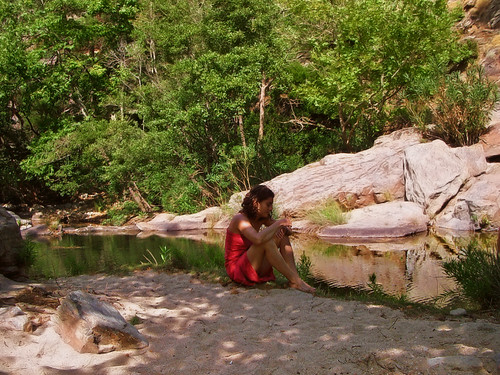
♦ This is the *Angelolivada* (river pool of 😳 angelic // XD diabolic fairies) near Nas.
♦ This pool was my first introduction to the sweet waters of Ikaria several years ago. Then I got myself better shoes and found better places. But still when I see it I can’t help taking a picture.
♦ This pool is *heritage* (because it IS haunted and legends about lethal encounters with fairies survive to this day).
♦ This pool is a *sight* (seen from close, the fall is HIGH and the pool is BIG -even though it’s lost almost half its size from stones and earth sliding down from the road above.)
♦ This pool is *sweet water* (rare stuff in the Aegean)
♦ This pool is a *pool* (you can swim in it.)It shouldn’t be left like this as if it was *nothing*. Yet it is. In spite it’s only 300 m. away from a small tourist resort, Nas. The beach of which is very small and unapproachable in high seas. To say more, it seems that people do their best to destroy it.
Yet the pool resists (because it IS haunted).And Ikaria will probably always remain *an unspoiled island*, as the hotel & tourist promoter claims.
Unspoiled means perhaps that piles of waste and rubble, abandoned wrecked cars, forever unfinished contructions and weird contraptions everywhere, goats competing with earthmovers to *shave* the best places … for nothing … not for money …just for nothing …because someone had *small idea* and why not after all? All this for me is not *unspoiledt-ness*. It’s just *lack of communication*, *selfishness*, *ignorance* and *confusion*.
I wish we were a little bit *spoilt* into common sense.
Fairies can’t do all the job by themselves (+pay for beds+breakfast too?…)
Or perhaps they can; I wouldn’t know.What I know is that
NATURE CAN’T BE WITHOUT CULTURE
(What we call *Nature* is a human invention, no?)
*NO CULTURE* or *WRONG CULTURE* = NO NATURE«Sometimes I feel like a motherless child» again. (I was a motherless child)
Sometimes I feel I can’t return to *the crazy island* because there’s just the craziness and the fun is gone. But then again my heart is strong (unlike my mother’s) and the *good craziness* and the fun is in mE.
I’ll deliver… 🙄
Comments
(4 total)
- greg
- Offline
(What we call *Nature* is a human invention, no?)
No I think not. It is what it is, completely indifferent to humanity, and so we destroy it instead of embracing it.
I have faith in you, since embrace it you do.
Friday June 16, 2006 – 07:45am (PDT)
- AKK
- Offline
To be honest El, we both chose to fall for a very compicated and difficult island and we suffer the consequences. How many times haven’t I told myself to fall in love with Mykonos/Ibiza instead. They are so easy like Lego and PlayMobil : white cubes laid on dry brown land and lots of (set up) parties with paid brazilian dancers…
But nooo ! Oooh, how deadly boring would that be !…
*Nature* is birth and death, both hardly conceivable. We see nature through culture. We used to have God to help us. Now we have to deal with it by ourselves. So culture becomes very important. But what am I talking about? Wasn’t it you who asked and received this genius answer about the mountains of Sezanne in southern France? His multiple paintings of the same and the same landscape actually saved the landscape. And we don’t have to discuss how heavy the building activity is in the South of France (no? -lol).
So go on being the Sezanne of Ikaria. Who knows? It may work.
As for myself I’ll go on digging and putting back the stones in place. Nail many signs too, so that you find your way and take your pictures.
P.S. good news ! ((: – I found an assistant – :)) It’s my 10 y.o. daughter. I pay her in ice-creams.
See her at work in my Flickr soon.
Friday June 16, 2006 – 08:58pm (EEST)
I knew of only one Cezanne’s «Montagne Sainte Victoire». The landscape could be anywhere in the Mediterranean, ok, but half of the results are Cezanne’s paintings. The rest are contemporary photos and other paintings.
(Any resemblance with Ikaria is purely coincidental)
That aristocratic *tall fat guy* Cezanne has really put a strong mark and actually saved that land -:)) He painted again and again the view from his villa and now the paintings have fused so much with the mountain (and the plain in-between) that nOoNe dAREs to touch this landscape!
See also : Wiki: Cezanne
I think they should teach this case in Fine Arts or Environmental Studies.
The tourist business (type «tourtour» -this is a village) benefited a lot and apparently many people find work. Cezanne has created a «tourist legend» too.
Is this *good machine», Nana?
Saturday June 17, 2006 – 12:44pm (PDT)
Bonjour *Paul(-ine) Cézanne* ! Comment ça va? 🙂
Oui, c’est une *trés bonne machine*. But people have to be informed and educated. And Ikaria is very unspoiled as far as this is concerned… 😦
Sunday June 18, 2006 – 03:14pm (EEST)
.
I walk, I hike, I wander
Δημοσιεύθηκε: 26 Ιουνίου, 2009 Filed under: choses vécues, exploring, hiking, ikaria, photography, stories | Tags: adventure, aegean, april, eleni-in-ikaria, elsa, enviro-lore, firewood, forest, Greece, hiking, ikaria, island in the aegean sea, χαζό-χαμόγελο, ικαρία, μονοπάτια, language, maratho, my life, my-neighbors, my-work, oxyzen, spring, trail-of-the-elves, trails, up-with-lonely-winter, walk-hike-wander, what-it-takes Σχολιάστε- .
-
 ..I walk ( I hike, as they say ), I wander on foot. That’s what I do all day. My hips ache. My lungs sometimes ache too because I’m a smoker; and because I’m half-mad & half Greek, I light my cigarette and I smoke it on the way up -ha,ha,ha 🙂
From the heights of my moral Himalayas I look down at everybody. Everybody? I hardly see anybody to look down at. I sometimes see from afar a plougher of a garden or of a vineyard.. .I don’t go near. I don’t know what to say to such people anymore (though once I used to -). To me
 they are the Presidents of (another Republic.
My moral altitude bothers me. Wuthering heights… It’s too lonely up here. I’ve gone up too many levels. The ‘Ikarian enigma» is solved. Everything is harmony – but I hate it.So I look around for spirits (‘gjins’) to keep me company. Thanks Gof, the place is full (as yet). It’s their mating season (gjins are not like humans -all the time-:lol:- gjins mate in April only; in May they stop, because it’s the donkeys’ turn).
They let me take pictures of them.. .
.I walk (I hike, as they say), I wander on foot. That’s what I do most days, sometimes on my own, sometimes with friends.
. .
..
 When I am back home, and I’ll have that stupid smile of bliss all over my face, my old neighbour will say «Eleni, you are a Porphyrogenita»!
.
Comments
(7 total)
Does the neighbor mean you are a princess?
Monday April 3, 2006 – 01:27pm (PDT)
correct -:- 🙂
in plain (minus the complicated historical background) language, the word means «serene» –
Monday April 3, 2006 – 02:00pm (PDT)
You are too modest
Monday April 3, 2006 – 10:40pm (BST)
serenissima / γαληνότατη, χαίρε !
Όσα ξέρει ο γείτονας/σσα σου για σένα, δεν τα ξέρει κανείς, ούτε ο ήλιος, ούτε κι εσύ. Ευτυχώς για σένα λοιπόν που έχεις γειτόνισσα την τέλεια ‘αντι-κατίνα’, μια ‘γαληνότατη’ της παλιάς σχολής. Είσαι τρομερά τυχερή. Επομένως μην γκρινιάζεις που κόβεται το ρεύμα τόσο συχνά στη γειτονιά σου. Δεν μπορείς να τα έχεις όλα, ε; 😉
Tuesday April 4, 2006 – 01:06pm (EEST)
- greg
- Offline
Born in the imperial purple room, yes?
Tuesday April 4, 2006 – 06:33am (PDT)
thanks; yes, born in the purple room!
It’s a strange local tradition to call noble calmness by that name. They say it comes from the times of Byzantium…
It’s a very strange thing for such an island! Click on the page to view it larger and read about the amazing fact!
Tuesday April 4, 2006 – 12:24pm (PDT)
The Trail of the Elves – Το Μονοπάτι των Ξωτικών (again!)
Δημοσιεύθηκε: 24 Ιουνίου, 2009 Filed under: choses vécues, exploring, hiking, ikaria, pleasure, stories, travel | Tags: aegean, ecotourism, explorers, February, Greece, hiking, hiking trails, ikaria, ikaria-in-winter, Ορειβατικός Πεζοπορικός Σύλλογος Ικαρίας, ΟΠΣ Ικαρίας, ικαρία, μονοπάτι των ξωτικών, μονοπάτια, links, map, monasteries, my-idea, OPS Ikarias, Theoktistis, trail-of-the-elves Σχολιάστε")
‘the trail of the elves’ >>:::>> THE MAP (at last)
 My good friend Angelos made the map of the trail we were talking about the other day . He also wrote a long long long text (once he starts he can’t stop) which we edited together and we left only a part of it. I hate cuttings on my texts, but I enjoy cutting other’s, so we sort of butchered it. For example, we left out the memories of his father as a school kid, what the first «school bus» looked like, what are his problems when building a new trail e.t.c. Anyway, I hope that what’s left makes sense.
Angelos apologizes for not having made a proper webpage for this. He says that even he had time to do it, he was afraid that there would be a misunderstanding : people might think that this is a «ready hike», while it is only a survey. So he let the map and the description look as sketchy as is the situation «in the field».
As far as I was concerned, it was an experience to witness how trails are actually made (in this case, «retrieved» or should I say, «re-invented»). It’s a *mind* thing. For example I had walked though many parts of that area and I could never have guessed that these «nice spots» were connected and there had been a long hikeway across them. I takes someone with a deep knowledge of the old culture to find this, dig it out and most of all,
GIVE A NEW CONTEXT to it.

 Eleni
Eleni
 Get the map and Read the description:

Here is an extract (view large) of a map of Ikaria showing the middle northern side of the island. This map was published in the small book under the title “Tourist Guide of the Municipality of Rahes, Ikaria” (Touristikos Odigos Demou Rahon Ikarias), issued in 2004 and distributed for free by the Municipality of Rahes (name of the western part of the island). This booklet was very good if not for anything else, because of the maps it contained. Unfortunately the stock is exhausted and it isn’t likely that there will be a new edition.
This map is in Greek only. It includes too many (very specific and unneeded) place names, which create ‘noise’ and confusion to the reader of a map. On the other hand, there is a good side in this pedantic ‘localism’: this is the only general map of Ikaria which shows the footpaths!!!
Almost forgotten today, the “trail of the two monasteries” (Eleni’s “trail of the elves”) used to be ‘the main road’ from Rahes to Evdilos until the late 1960s when a motor road was built to connect the two towns.
If ever this path was restored, I’d suggest that hikers take it from Rahes. On a long hike like this, it’s always better to head for the sea instead for the mountain.
From Christos in Rahes ((ΧΡΙΣΤΟΣ ΡΑΧΕΣ) to the 1st monastery (Evangelistrias ‘Mounte’ monastery -Μονή Μουντέ), the area is inhabited. The ‘wild part’ of the hike starts after the lake ‘Μικρό Φράγμα’, across deep pine and oak forests, machia and bushlands, over hills and across mountain streams with pools and falls. There are many low tone ‘anonymous’ sights (‘lowlights’ to use one of Eleni’s own terms).
I wasn’t supposed to deal with this path. I’d rather have waited for the authorities to show some interest. Instead of looking for ‘trails of the elves’, I’d rather work to improve the solid paths included in the ‘Round of Rahes on Foot’. But curiosity took the better of me, as it always does.
A first long survey proved that the path was still there (of course many parts were altered, covered in growth, ‘eaten’ by roads- but most of it was there!). Then I took my cutter and cleaned some parts as far as the mountain stream “Chalikias” (Χαλικιάς). It was a comfort for me to find occasional marks in red paint made by hiking parties a long time ago. I added a few stonemarks too. I usually do this when scouting, so that I am able to find my way back!..
After Chalikias I got involved in a very deep forest and if the path was not so well made I would never have found it. Anyway, after quite long I somehow managed to reach Lidi (“Λίδι”), where I came out in a narrow dirt road going the right direction -west!
*(They are about to build a small irrigation dam in Lidi right where the path comes out of the forest. When I made it there, covered in dust and sweat, I so much wished it was ready and I could take a dip!)
From Lidi I followed the road to the 2nd monastery (Theoktistis Monastery, see Eleni’s blog entry: “highlights»), which is very near the village of Pigi (ΠΗΓΗ). From there I walked to the main road (Evdilos-Pigi) and I waited for a friend to pick me up. There are three small whitewashed old churches on the eastern side of that road. That’s where the path goes on from Pigi to Kampos (and then Evdilos). These three churches are important landmarks.
Though I didn’t walk any further and I don’t have first hand knowledge, I can assume that the area along the stone paved mule track from Pigi to Kampos is very beautiful. These hillsides under the villages of Pigi (ΠΗΓΗ), Maratho (ΜΑΡΑΘΟ), and Frantato (ΦΡΑΝΤΑΤΟ), have the privilege to face the east and there are many springs, good soil, limestone and … no goats! So I’m sure they would be covered with flowers in spring!
NOTES:
1) The green lines on the map are the ‘traditional‘ paths. Some of them have become roads; some have disappeared. The dark purple lines represent the paths of the system of the Round of Rahes of Foot which, unlike the green ‘theoretical’ or traditional paths, is a reliable and well marked network of hiking trails.
2) I’ve drawn the ‘trail of the 2 monasteries’ in pink, because this colour makes a good contrast with the colours of the map. If you are good at Photoshop, you can put my map as ‘layer’ on a scanned image of the Road map (which you should first make smaller to fit the scale). Then you can erase all other info from my map and leave only the pink lines. It would be interesting to see if and how they fit on the Road map.
3) Besides the “trail of the 2 monasteries” (west-east, I’ve also painted pink the path in Myrsonas (Μύρσωνας) river (south-north), though this path is not ‘elfish’ but a reliable hike already included in The Round of Rahes on Foot. I did this because the Trail in Myrsonas is very closely associated with the ‘trail of the 2 monasteries’. The western startpoint of the trail of the 2 monasteries is situated right in it (in a place called “Φυρή Άλωνα”, marked with a pink arrow in the map).
4) The motor road between Rahes and Evdilos is exactly 17 km long. I estimate that the pink path from “Φυρή Άλωνα” to Kampos must be about 10 km long. Good news: a) there are no steep climbs up and downs. More good news: more than half of this hike is on secondary country roads (not shown in this map)!
5) the pink path ends (or begins) in the square of the village of Kampos, near the church of Agia Irini (“Αγ. Ειρήνη”), which is marked in the map with a “church” symbol. For the time being, however, I don’t advise you to hike all the way down there on the trail, because the last part of it goes through the village and gets very confusing. Instead of this, head for the main roads above Kampos. So, as you hike down from Pigi, after “Καλανταρέ” you will meet a narrow dirt road; there leave the path and follow the road to the left; it will lead you to the main motor road to Pigi (I marked this spot with a pink arrow on the map) and then out on the main road Armenistis-Evdilos (I’ve marked that spot with a pink arrow too).
6) This is a sketch of a map and a sketch of a description. Do not expect from me to give you altitudes, exact distances, e.t.c. Even the pink line I’ve drawn, I’m not at all sure if it fits in a proper geographical map. This is something that I did because I like it and because I very much like to share it with you.
7) Inspite of the beauty of the land, there is no policy whatsoever for the environment or for ecotourism in Greece. My fellow country men are only just now starting to grow an awareness in these issues. So when you hike, do not take things for granted. Take the situation in your hands (or rather, ‘your feet’)and behave like explorers: a) never get sore if you are lost; there is fun in it! b) when you see piles of stones as marks in the paths, repair them if possible and maybe add on some more.
8) I may have made mistakes. Make your comments and ask your questions (preferably in English or Greek, though any language is good) in http://www.facebook.com/groups/hikingIkaria/
Comments
(4 total)
Sorry, the image of the map I uploaded here, came out very very small. You can see it large HERE.
Thursday February 23, 2006 – 03:32am (PST)
- greg
- Offline
Could only read the unjustified text, had to scroll right-left, right-left, but very nice description. Could have read more Elle, let him rip next time!
Thursday February 23, 2006 – 07:36am (PST)
Sorry people. That was what we say a ‘very rough draft’. I just wanted to make my point: these places exist, can be charted and described.*the mind* says : may the force be with you Elle, you are unbelievable :)) make me get back in this business so soon after…
Thursday February 23, 2006 – 10:47pm (EET)
The trail where you meet no people for 9,5 kilometers! ONLY NATURE!
x x x x

Saturday February 25, 2006 – 09:18pm (EET)
The Trail of the Elves in Ikaria
Δημοσιεύθηκε: 24 Ιουνίου, 2009 Filed under: choses vécues, exploring, hiking, ikaria, photography, stories | Tags: adventure, aegean, architecture, destiny, ecotourism, empty-landscapes, Greece, green-investments, hiking, hiking trails, ikaria, ικαρία, μονοπάτι των ξωτικών, μονοπάτια, map, monasteries, new-trail, Theoktistis, trail-of-the-elves, walk-hike-wander 3 Σχόλια

 please don’t think that this is another tale ! On the contrary this going to be quite technical. We call this path «the trail of the two monasteries» because it stretches between the monastery of Mounte and the monastery of Theoktistis.


Comments
(1 total)

Here is an extract of a map of Ikaria showing the middle northern side of the island.
This map was in the small book «Tourist Guide of the Municipality of Rahes, Ikaria» (Touristikos Odigos Demou Rahon Ikarias), issued in 2004 and distributed for free by the Municipality of Rahes (name of the western part of the island). This booklet was very good if not for anything else, because of the maps it contained. Unfortunately the stock is exhausted and it isn’t likely that there will be a new edition.
This map is in Greek only. It includes too many (very specific and unneeded) place names, which create ‘noise’ and confusion to the reader of a map. On the other hand, there is a good side in this pedantic ‘localism’: this is the only general map of Ikaria which shows the footpaths!!!
Almost forgotten today, the «trail of the two monasteries» (Eleni’s «trail of the elves») used to be ‘the main road’ from Rahes to Evdilos until the late 1960s when a motor road was built between the two towns.
If ever this path was restored, I’d suggest that hikers take it from Rahes. On a long hike like this, it’s always better to head for the sea instead for the mountain.
From Christos in Rahes ((ΧΡΙΣΤΟΣ ΡΑΧΕΣ) to the 1st monastery (Evangelistrias ‘Mounte’ monastery -Μονή Μουντέ), the area is inhabited. The ‘wild part’ of the hike starts after the lake ‘Μικρό Φράγμα’, across deep pine and oak forests, macchia and bushlands, over hills and across mountain streams with pools and falls. There are many low tone ‘anonymous’ sights (‘lowlights’ to use one of Eleni’s own terms).
I wasn’t supposed to deal with this path. I’d rather have waited for the authorities to show some interest. Instead of looking for ‘trails of the elves’, I’d rather work to improve the solid paths included in the ‘Round of Rahes on Foot’. But curiosity took the better of me, as it always does.
A first long survey proved that the path was still there (of course many parts were altered, covered in growth, ‘eaten’ by roads- but most of it was there!). Then I took my cutter and cleaned some parts as far as the mountain stream «Chalikias» (Χαλικιάς). It was a comfort for me to find occasional marks in red paint made by hiking parties a long time ago. I added a few stonemarks too. I usually do this when scouting, so that I am able to find my way back !..
After Chalikias I got involved in a very deep forest and if the path was not so well made I would never have found it. Anyway, after quite long I somehow managed to reach Lidi («Λίδι»), where I came out in a narrow dirt road going the right direction -west!
* (They are about to build a small irrigation dam in Lidi right where the path comes out of the forest. When I made it there, covered in dust and sweat, I so much wished it was ready and I could take a dip !)
From Lidi I followed the road to the 2nd monastery (Theoktistis – Μονή Θεοκτίστης) which is very near the village of Pigi (ΠΗΓΗ). From there I walked to the main road (Evdilos-Pigi) and I waited for Nana to pick me up on her bike. There are three small whitewashed old churches on the eastern side of that road. That’s where the path goes on from Pigi to Kampos (and then Evdilos). These three churches are important landmarks.
Though I didn’t walk any further and I don’t have first hand knowledge, I can assume that the area along the stone paved mule track from Pigi to Kampos is very beautiful. These hillsides under the villages of Pigi (ΠΗΓΗ), Maratho (ΜΑΡΑΘΟ), and Frantato (ΦΡΑΝΤΑΤΟ), have the privilege to face the east and there are many springs, good soil, limestone and … no goats! So I’m sure they would be covered with flowers in spring!
NOTES:
1) The green lines on the map are the ‘traditional‘ paths. Some of them have become roads; some have disappeared. The dark purple lines represent the paths of the system of the Round of Rahes of Foot which, unlike the green ‘theoretical’ or traditional paths, is a reliable and well marked network of hiking trails.
2) I’ve drawn the ‘trail of the 2 monasteries’ in pink, because this colour makes a good contrast with the colours of the map. If you are good at Photoshop, you can put my map as ‘layer’ on a scanned image of the Road map (which you should first make smaller to fit the scale). Then you can erase all other info from my map and leave only the pink lines. It would be interesting to see if and how they fit on the Road map.
3) Besides the «trail of the 2 monasteries» (west-east, I’ve also painted pink the path in Myrsonas (Μύρσωνας) river (south-north), though this path is not ‘elfish’ but a reliable hike already included in The Round of Rahes on Foot. I did this because the Trail in Myrsonas is very closely associated with the ‘trail of the 2 monasteries’. The western startpoint of the trail of the 2 monasteries is situated right in it (in a place called «Φυρή Άλωνα», marked with a pink arrow in the map).
4) The motor road between Rahes and Evdilos is exactly 17 km long. I estimate that the pink path from «Φυρή Άλωνα» to Kampos must be about 10 km long. Good news: a) there are no steep climbs up and downs. More good news: more than half of this hike is on secondary country roads (not shown in this map)!
5) the pink path ends (or begins) in the square of the village of Kampos, near the church of Agia Irini («Αγία Ειρήνη») which is marked in the map with a «church» symbol. For the time being, however, I don’t advise you to hike all the way down there on the trail, because the last part of it goes through the village and gets very confusing. Instead of this, head for the main roads above Kampos. So, as you hike down from Pigi, after «Καλανταρέ» you will meet a narrow dirt road; there leave the path and follow the road to the left; it will lead you to the main motor road to Pigi (I marked this spot with a pink arrow on the map) and then out on the main road Armenistis-Evdilos (I’ve marked that spot with a pink arrow too).
6) This is a sketch of a map and a sketch of a description. Do not expect from me to give you altitudes, exact distances, e.t.c. Even the pink line I’ve drawn, I’m not at all sure if it fits in a proper geographical map. This is something that I did because I like it and because I very much like to share it with you.
7) Inspite of the beauty of the land, there is no policy whatsoever for the environment or for ecotourism in Greece. My fellow country men are only just now starting to grow an awareness in these issues. So when you hike, do not take things for granted. Take the situation in your hands (or rather, ‘your feet’)and behave like explorers: a) never get sore if you are lost; there is fun in it! b) when you see piles of stones as marks in the paths, repair them if possible and maybe add on some more.
8) I may have made mistakes. Make your comments and ask your questions (preferably in English or Greek, though any language is good) in http://www.facebook.com/groups/hikingIkaria/
Angelos Kal -21/02/2006
Friday February 17, 2006 – 01:18pm (EET)
a path and a poll
Δημοσιεύθηκε: 24 Ιουνίου, 2009 Filed under: choses vécues, exploring, hiking, ikaria, stories, travel | Tags: adventure, aegean, eleni-in-ikaria, empty-landscapes, explorers, February, hiking, hiking trails, ikaria, ikaria-in-winter, ικαρία, μονοπάτι των ξωτικών, μονοπάτια, new-trail, poll, preservation, trail-of-the-elves, trails, walk-hike-wander Σχολιάστε-


Let’s have a poll.

I discovered a trail yesterday. It’s actually much more than a trail or an intervillage lane. It’s an old all-stone-paved a few km long mule track, what we’d call a highway today. It used to connect the villages in the mountains with the coast (=the rest of the world). So you understand how important it was and why it was so well and wisely constructed. This avenue dates from the 19th century when the rural economy of the island flourished.
Today there’s just one old man who still uses it.
He leads his cows and sheep from his farm (in the mountain village) to the lower pastures near the coast. This track is not to be found in any map, not even AKK’s. His hiking map (and the associated preservation project) does not extend so as to cover this area. There were only some very old faded marks -a sign that some hikers had used it once long ago when the path was more clear without so much undergrowth, branches and bush.
I’m not an architect or a traditionalist or even less a local lobbist, fund raiser, volunteer etc. but this time I was tempted to do something about it. So what’s your opinion:
 1) Should I tell the Mayor to clean it? He’ll probably say ‘yes, yes, sure’, get rid of me and then forget about it.
 2) Should I work together with AKK and clean it together? We’d better not, It’s too far from his base and he already has a lot of trails to look after.
 3) Should I tell the nearest hotel owners («look, this is good for tourism etc.»). They might think (perhaps even say it) «why do you care?», «are you in the business?» and that kind of thing. At best they’d say «you go on and start it yourself because you have more time and we will come later.» (but ‘later’ in Ikaria often means ‘never’.)
 4) I could call everybody I know and launch them on the mountain. They’d clean the track in two days! But this means I’d have to cook at least 4 meals for at least 8 people and though I can afford the food and the wine, I hate cooking very much and I’m not good at it and inviting them to a restaurant would be too expensive.
………………

-
 5) Should I leave the path as it is? It’s not so bad after all what do you think? (another romantic ruin? -what) But if it’s nice to see, it’s not easy to walk on and fight your way through branches and thorns etc.
 6) Should I leave the path as it is? Who am I to say? They don’t want it. It’s past. Perhaps also it makes them sad. And the Mayor would say, «yes of course, that path -oh, how many memories, etc.- but you see now we are building roads and it’s so difficult because the government doesn’t help (more etceteras) places like Ikaria (etceteras long to reach Mars). By the way, do you vote here?» This is what most mayors are. So (?) let it grow and disappear (?).
Am I crazy to be jealous (Nana often accuses me) of those parks and reserves in other countries and even some in Greece too? I’m deeply in love with my OPEL but I am polyamorous and I love paths as well ! They take you to meaningful places and you get inside them from very interesting ‘natural’ angles. They make stories and is why perhaps some of my photos in Flickr are succesful.
Comments
(5 total)
- simon
- Offline
First of all tell me where the path is… it looks like one saw between Avlaki and Mandria. I will help clear it with pleasure, it looks very inviting.
Wednesday February 15, 2006 – 09:28pm (GMT)
- greg
- Offline
The one who still uses it should have a say. I wouldn’t decide w/o his counsel.
Wednesday February 15, 2006 – 05:06pm (PST)
Ελένη, αν ψάχνεις για μαλ…κες, το ξέρεις -είμαι μέσα και βάλε με στη λίστα. Όμως γιατί μου φαίνεται πως κάτι άλλο θες να πεις;
Thursday February 16, 2006 – 10:25am (EET)
-


")


")


Πρόσφατα σχόλια